Book Tickets Online
About
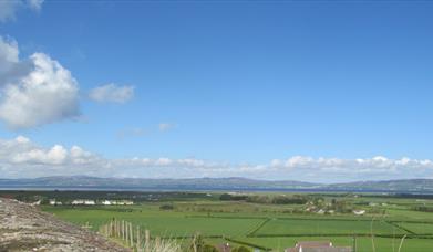
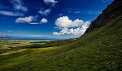
Gortmore to Hell's Hole offers a short upland walk along a section of the North Sperrins Way/Ulster Way offering great views to Binevenagh, Lough Foyle, Inishowen, the Causeway Coast and to Islay and Jura. Boots and appropriate clothing are recommended on this route. Please note no dogs are permitted due to grazing livestock. The route offers a combination of upland fields and walking along a public road. The nearby sculpture of Manannan Mac Lir keeps watch over the mouth of Lough Foyle from the start of the route.
ROUTE DESCRIPTION
On entering Gortmore Viewpoint from the car park, turn left immediately across the grass and look for a stile to cross the fence near the cliff line IC 715 342.
Head south keeping the fence line on your right with the distinct outline of Binevenagh...Read More
About
Gortmore to Hell's Hole offers a short upland walk along a section of the North Sperrins Way/Ulster Way offering great views to Binevenagh, Lough Foyle, Inishowen, the Causeway Coast and to Islay and Jura. Boots and appropriate clothing are recommended on this route. Please note no dogs are permitted due to grazing livestock. The route offers a combination of upland fields and walking along a public road. The nearby sculpture of Manannan Mac Lir keeps watch over the mouth of Lough Foyle from the start of the route.
ROUTE DESCRIPTION
On entering Gortmore Viewpoint from the car park, turn left immediately across the grass and look for a stile to cross the fence near the cliff line IC 715 342.
Head south keeping the fence line on your right with the distinct outline of Binevenagh Mountain and the expanse of Lough Foyle in front of you (visibility permitting of course). You are now walking through the townland of Gortmore. The trail flows gently downhill through this grazed upland area, after approximately 400 metres you meet a small headland IC 714 338. Take the time to look northwards from this point to view one of the largest sand dune systems in the UK & Ireland that forms part of Magilligan Special Area of Conservation as well as the classic land slips below the cliff line.
Continue south wards along the fence line as the alluvial plain of Magilligan spreads out below you to the west. Many of the fields immediately below the cliff feature stone walls and have an undulating topography that contrasts with the larger level fields that stretch down to meet with the Lough Foyle shore.
The area around the Duncrun Road is a raised beach and is home to a range of archaeological features. Keep following the fence line to meet an old iron gate which forms part of a ‘slap’, IC 711 330 turn left to follow the fence uphill a short distance and then continue on to sweep round to meet a stile to take you onto the Bishop’s Road IC 713 326. You skirt past Hell’s Hole, a distinctive gulley which is best seen from the Duncrun Road or Seacoast Road. Please note that Hell’s Hole is not publicly accessible.
Cross the stile and carefully turn left onto the Bishop’s Road keeping an eye out for traffic and follow the road north for 1.5 kms as it climbs gently to return to Gortmore Viewpoint. Please note this walk can be combined with the Avish to Eagles Hill route to make a 5 mile long route.
Facilities
Parking & Transport
- Car parking
- Parking (free)